



Integrating Drone Surveying Into Construction Workflows
Table of Contents
- Integrating Drone Surveying Into Construction Workflows: An Overview
- Step 1: Establish Your Baseline With Drone Mapping for Construction Sites
- Step 2: Validate Drone Surveying Accuracy and Ground Control Points
- Step 3: Convert Drone Survey Data to BIM for Design Coordination
- Step 4: Implement Drone Construction Progress Monitoring
- Integrating Drone Data Into Your Existing Construction Software and Processes
- Managing Accuracy Limitations and Regulatory Requirements
- Measuring ROI: Time Savings, Cost Reduction, and Risk Mitigation
- Frequently Asked Questions
Last Updated: October 13, 2026
Integrating Drone Surveying Into Construction Workflows: An Overview
Drone surveying transforms how construction teams capture site data.
At The Next Idea Group, we work with construction teams across hospitality, multi-unit franchise development, and commercial real estate. Integrating drone surveying into construction workflows can eliminate delays, reduce rework, and give stakeholders real-time visibility into site conditions.
This guide covers the full implementation path: establishing baseline site data, design coordination, and ongoing progress monitoring.
Step 1: Establish Your Baseline With Drone Mapping for Construction Sites
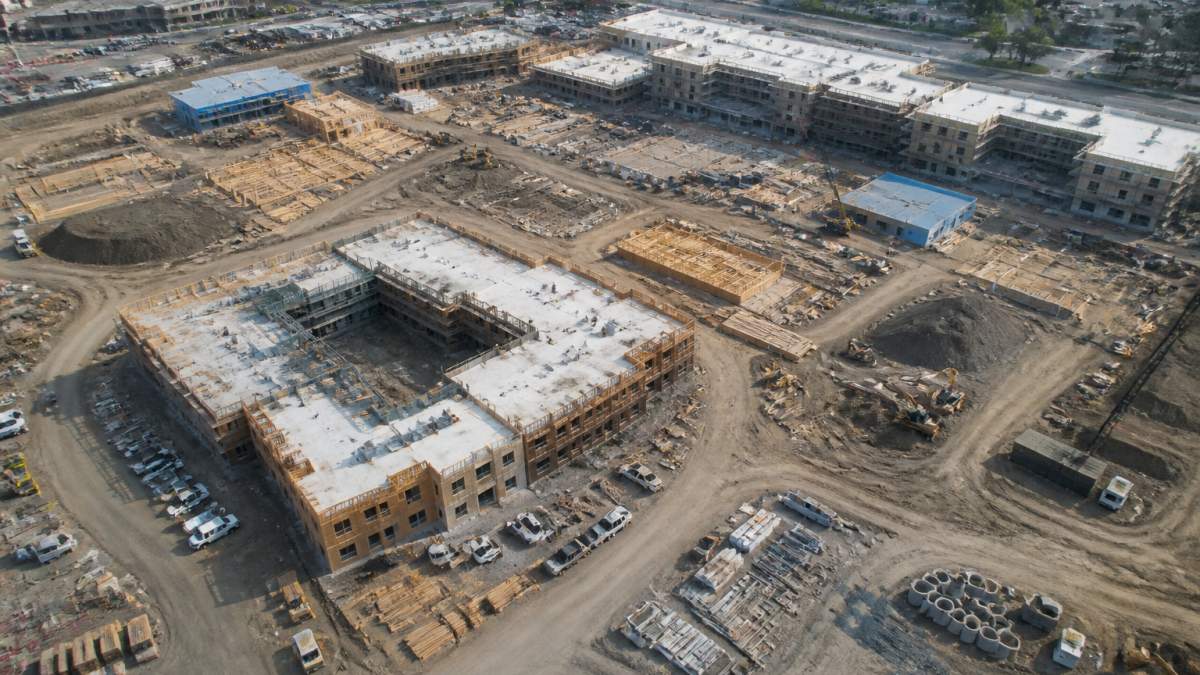
Your first drone mission captures the foundation for everything that follows. This baseline establishes existing conditions before construction begins, creating a reference point for design decisions, compliance documentation, and future progress comparisons.
Define Your Capture Objectives
Start by asking what decisions this data must support. Different project phases need different data types.
For pre-construction planning, you need orthomosaics (georeferenced aerial images stitched into a seamless map) and point clouds (3D data showing terrain elevation, structures, and utilities).
Common capture objectives include:
- Terrain mapping and elevation data for grading and drainage design
- Existing building footprints and roof conditions for renovation projects
- Utility line locations and clearances for site safety planning
Document these objectives before you fly. They determine your flight altitude, camera settings, and ground control point placement.
Plan Your Flight Path and Ground Control Points
Flight planning is the backbone of accurate drone surveying.
Standard practice calls for 80% forward overlap and 60% side overlap.
Ground control points (GCPs) are physical markers you locate with survey-grade GPS.
For a typical construction site:
- Place 5-15 GCPs depending on site size and terrain variation
- Space them across the survey area, not clustered in one corner
- Use high-contrast targets (white and black checkerboards) so the drone camera can locate them precisely
Without GCPs, your drone data is geometrically accurate but spatially “floating”, it has no fixed relationship to the coordinate system your engineers use.
Step 2: Validate Drone Surveying Accuracy and Ground Control Points
Accuracy isn’t binary. Different project phases tolerate different error margins. A 2-inch error matters for building footprint verification but not for stockpile volume estimates. Understanding these tolerances prevents wasted processing effort and unrealistic expectations.
Understanding Georeferencing and Coordinate Systems
Georeferencing anchors your drone data to a specific location on Earth.
Your project uses a specific coordinate system: State Plane, UTM, or a local survey datum. Your GCPs must be measured in that same system.
Coordinate system mismatches cause integration failures downstream. If drone data is referenced to a different datum than your BIM model, the two won’t align.
Quality Assurance for Your Aerial Data
After processing, validate your point cloud and orthomosaic before you hand them to your design team. Common quality checks include:
- Point cloud density: 500+ points per square meter is typical for construction-grade work. Sparse areas suggest image overlap problems or processing errors.
- Orthomosaic seams: Look for visible stitching lines, color shifts, or geometric distortions where images join. These indicate alignment problems.
- GCP residuals: Your processing software reports how far each GCP’s measured location differs from its calculated location. Residuals under 0.1 feet indicate good accuracy. Residuals over 0.3 feet suggest GCP measurement errors or image processing issues.
If quality checks fail, the cause is usually poor GCP measurements, insufficient image overlap, or processing parameter errors. Identify it before you re-fly or reprocess.
Step 3: Convert Drone Survey Data to BIM for Design Coordination
Your baseline drone data becomes a powerful design coordination tool when integrated into your BIM model. This is where drone surveying shifts from documentation to active project intelligence.
Processing Point Clouds and Orthomosaics
Point cloud processing converts raw drone images into 3D geometry.
Orthomosaics are georeferenced aerial images. The software stitches overlapping images into a seamless map, correcting perspective distortion so vertical features appear true.
Both outputs serve different purposes. Point clouds show volumetric detail: roof slopes, terrain undulation, and existing structures in 3D space.
Processing typically takes 4-24 hours depending on site size and point density.
Integrating Data Into Your BIM Model
Your BIM model is the single source of truth for your project. Drone data enters as a reference layer, a visual and geometric anchor that keeps design decisions grounded in actual site conditions.
Common integration approaches:
- Point cloud as reference geometry: Import the point cloud into your BIM software as a background layer. Designers can snap new model elements to the point cloud, ensuring alignment with existing conditions.
- Orthomosaic as site base plan: Attach the orthomosaic as a raster image in your BIM plan view. It replaces hand-drawn site surveys with photographic reality.
- Mesh models for complex existing conditions: For renovation projects with intricate existing structures, convert the point cloud to a mesh surface. This gives you smooth geometry to work with instead of millions of discrete points.
The integration step connects drone surveying to your design workflow. Without it, drone data sits in a separate folder, disconnected from decisions.
Step 4: Implement Drone Construction Progress Monitoring
Once construction begins, drone surveying shifts from baseline documentation to ongoing surveillance. Recurring flights create a visual and geometric record of progress, safety conditions, and site changes.
Setting Up Recurring Capture Schedules
Progress monitoring flights follow a regular schedule: weekly, bi-weekly, or monthly depending on project pace and stakeholder needs. Consistency matters.
Establish a flight protocol that your drone team follows every time:
- Same launch location and altitude
- Same flight path and image overlap settings
- Same time of day (controls shadow angle and lighting consistency)
This consistency makes month-to-month comparisons valid. Overlay orthomosaics from month 1 and month 6 to see exactly what changed: building progress, equipment movement, and site conditions.
Document each flight: date, weather, pilot notes, any site access issues. This log becomes part of your project record and helps explain anomalies in the data.
Comparing As-Built Conditions to As-Planned Models
Progress monitoring’s real value emerges when you compare actual site conditions to your design model, catching misalignment early.
Overlay your current orthomosaic on your BIM plan view to spot where building locations, material stockpiles, and site conditions differ from the plan.
Common comparisons include:
- Building footprints: Are structures positioned correctly relative to property lines and neighboring buildings?
- Excavation progress: Has grading reached the planned elevation?
- Material staging: Are stockpiles in designated areas, or encroaching on traffic paths?
These comparisons inform weekly progress meetings. Project managers, architects, and contractors see the same visual data, no ambiguity about what’s actually happening on site.
Integrating Drone Data Into Your Existing Construction Software and Processes
Drone surveying doesn’t replace your existing workflow. It augments it. Success depends on connecting drone data to the software and processes your team already uses.
Workflow Roles and Responsibilities
Define who does what. Typical roles include:
- Drone pilot: Conducts flights, manages equipment, ensures safety compliance. May be in-house or contracted.
- Data processor: Runs photogrammetry software, validates point clouds and orthomosaics, delivers processed data to the team.
- BIM coordinator: Imports drone data into the model, maintains coordinate system alignment, ensures design team uses current site information.
Clear role definition prevents data from getting lost in handoffs. Each person knows their responsibility and what they receive from the previous step.
Data Management and Security
Drone surveys generate large files. A single site survey might produce 10-50 GB of raw images plus processed point clouds and orthomosaics.
Most teams use cloud storage: Dropbox, Google Drive, or construction-specific platforms like Autodesk Construction Cloud. Cloud storage provides:
- Version control (you can track which orthomosaic is current)
- Access control (only authorized team members see site data)
- Automatic backup (no single point of failure)
- Mobile access (field teams can view current data on tablets)
Document your data management protocol: where files live, who has access, how long you retain them, how you name files for easy retrieval.
Security matters. Construction site data shows building layouts, security measures, and equipment locations. Unauthorized access creates liability.
Managing Accuracy Limitations and Regulatory Requirements
Drone surveying delivers remarkable value but has real limits. Understanding them prevents misapplication and keeps your project compliant.
When to Use Survey-Grade Accuracy vs. Drone Estimates
Drone surveying typically achieves 0.1 to 0.5 feet of horizontal accuracy with ground control points, excellent for progress monitoring, design coordination, and site visualization, but not survey-grade.
True survey-grade accuracy, 0.01 feet or better, requires licensed surveyors with certified equipment. Use it for:
- Property boundary verification (legal liability if wrong)
- Utility location (safety-critical)
- Setback and zoning compliance (regulatory requirement)
- Easement and right-of-way documentation
Use drone surveying when you need site context and geometric accuracy for design and progress tracking, but not legal survey certainty.
Safety and Compliance Considerations
Drone operations are regulated. The FAA requires:
- Remote pilot certification (Part 107)
- Visual line of sight during flight
- Airspace clearance (no flying near airports or in restricted airspace)
- Liability insurance
Some sites have additional restrictions. Hospitals, military installations, and secure facilities often prohibit drones entirely, so verify site access before planning a flight.
Document your safety practices, brief your site team on drone operations, and establish exclusion zones during flights. These precautions protect your team and limit liability.
Measuring ROI: Time Savings, Cost Reduction, and Risk Mitigation
The business case for integrating drone surveying into construction workflows rests on three pillars: time, cost, and risk.
Time savings emerge immediately. A manual site survey takes days; a drone flight takes hours.
Cost reduction compounds over a project.
Risk mitigation is harder to quantify but equally valuable.
The Next Idea Group integrates drone surveying data into our site survey and as-built documentation services.
Frequently Asked Questions
How do you integrate drone survey data into a construction workflow?
Drone data flows through four main stages: capture and georeferencing, quality validation, conversion to BIM-compatible formats (point clouds and orthomosaics), and integration into your design coordination platform. Your project team establishes ground control points for accuracy, processes the raw data into usable spatial models, and imports those models into BIM software alongside your as-planned designs. This allows architects, engineers, and contractors to compare actual site conditions against design intent and track progress over time. The workflow requires clear roles, who captures data, who processes it, who approves quality, and who integrates it into project systems, to avoid bottlenecks.
What are the main limitations of drone surveying on construction sites?
Drone surveys typically achieve accuracy within 2-5 centimeters horizontally, which is sufficient for progress monitoring and design coordination but may not meet survey-grade standards (sub-centimeter) required for final as-built documentation or boundary surveys. Weather, site obstructions, and GPS signal strength affect data quality. Drones cannot capture data indoors or beneath dense tree cover. For projects requiring legal survey certification or precise utility location, combine drone data with traditional surveying. Understanding these boundaries helps you allocate drones to the tasks they handle best, progress tracking, site visualization, stockpile measurement, while reserving licensed surveyors for compliance-critical deliverables.
How often should a construction site be surveyed with a drone for progress monitoring?
Frequency depends on project phase and pace. During active construction, weekly or bi-weekly flights capture meaningful progress and identify schedule deviations early. During slower phases (permitting, material procurement), monthly flights suffice. High-risk areas, excavation zones, safety-critical work, areas prone to change orders, warrant more frequent capture. Establish a recurring schedule at project kickoff and document it in your construction management system so crews expect the flights and plan site access accordingly. Consistent intervals make it easier to generate time-lapse visualizations and track cumulative progress against the schedule.
What data formats from drone surveys work with BIM software?
Standard BIM platforms (Revit, Navisworks, OpenBIM formats) accept point clouds in LAS or LAZ format and orthomosaics as GeoTIFF or georeferenced imagery. Processing software converts raw drone imagery into these formats during post-flight work. Ensure your drone service provider or in-house processing team delivers data with proper georeferencing (coordinate system, elevation reference) so it aligns correctly with your BIM model’s coordinate system. Misaligned data creates coordination problems downstream. Confirm format compatibility with your BIM software and project standards before your first flight so data flows smoothly into your design and coordination workflows.
Integrating drone surveying into construction workflows requires clear processes, defined roles, and realistic expectations about accuracy. The payoff, faster decisions, better coordination, and lower risk, justifies the investment in planning and execution. Contact The Next Idea Group today to discuss how drone surveying can support your next construction project.